By Dave Jones
As much as bicycles rule the road at UC Davis, the fact remains that sometimes cyclists can "feel like the peanut butter in a sandwich."
In other words, squished between cars and pedestrians.
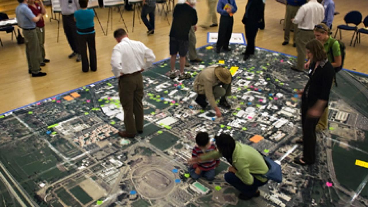
An unidentified bicyclist wrote the peanut butter metaphor on a Post-it note and stuck it on a giant map during last week's public workshop that launched the Davis campus's Bikeway and Transit Network Study. The university is using the study to help set priorities for transportation improvements and meet the campus's needs for the next 20 years.
Workshop organizers had not yet tallied the comments, but "before we rolled up the map, we estimated 200 to 300," said Matt Dulcich, who is leading the study for the Office of Resource Management and Planning.
"We were amazed at the number," he said. "We realized that in some respects the people who use the system daily are the experts, and their comments are what we needed to kick off the study."
Dulcich said 80 people signed up for either of two workshop sessions, one in the early afternoon, the other in the evening, in Freeborn Hall. Spread out on the floor was a 600-square-foot map, printed from aerial photographs, taking in all 900 acres of the core campus and more, from the future home of West Village at Highway 113 and Russell Boulevard to the Borders bookstore in downtown Davis.
Planners invited bicyclists, pedestrians and motorists to walk all over the map and identify what worked and what did not in the campus's network of bike paths, sidewalks and roads.
The map offered people "a positive way to become engaged," Dulcich said. "They stood exactly where they thought there was a problem, and they showed us."
Some of those problems involved injury reports. One Post-it note described an incident on the trail between the Segundo Dining Commons and the underpass at La Rue Road: "Friend forced off road into dirt, tire skipped, mild concussion."
The "peanut butter" Post-it marked the intersection of north-south La Rue and Anderson roads, and east-west Russell Boulevard, at the northwest corner of the core campus.
"When going south on Anderson crossing to dorms (Segundo residence halls), I feel like the peanut butter in a sandwich and try to avoid," the Post-it's writer said.
Dulcich said the Bikeway and Transit Network Study will examine the La Rue-Anderson-Russell intersection and all other transition points between the city and the campus.
"We need to take a careful look at every spot where the road system intersects with the campus's bike system," Dulcich said.
Many Post-it notes encouraged better bike-pedestrian separation, for example, on the north-south route between the soccer-lacrosse field and Mann Hall, south of the Segundo residence hall area.
Dulcich said the solution there may be a wider path or parallel paths — something to be addressed in standards that will be part of the forthcoming transit network plan.
Yet, even where bicyclists and pedestrians are already separated, they do not always stick to their assigned paths. Case in point: the backside of Shields Library where a north-and-south path runs between the library and Olson Hall. The wide, sunken path runs under a bridge — and should be reserved for bicyclists, said Elisa Hough, a senior English major.
"There's plenty of walking space on either side," she said. The walking paths are at ground level, connected by the wooden bridge.
"When people walk under the bridge, they're getting in the way of bicyclists who are going at higher speed."
John Fulton, a 2004 design graduate who now works as exhibition coordinator at the Design Museum, cited a similar concern in front of Hoagland Hall. The university maintains parallel walkways and bike paths on this route, but bicyclists and pedestrians often take the wrong path.
"We need some sort of signage so bikers and pedestrians know where they are supposed to go," Fulton said. He added that "simple signage could probably solve most of the problems on campus."
Dulcich said some people might argue that adding more signs would clutter the campus, "so we must balance additional signs with the benefit they would bring."
The area that seemed to get the most Post-it notes was the Activities and Recreation Center, understandable, because it is a major hub of student and staff activity from early morning to late night.
People opined on missing links and poor connections, routes that are too narrow, not enough bicycle parking, and collisions at the traffic circle. One person suggested a bicycle lane on the entry street that connects La Rue Road and the parking lot in front of the ARC.
Dulcich said campus planners are well aware of the congestion at the ARC, "and we are encouraged by all the detailed comments."
"Although people have frustration, they are willing to jump in with great ideas."
Dulcich and an outside firm, Walnut Creek-based Fehr & Peers Transportation Consultants, are now recording and analyzing the comments, in preparation for developing an improvement plan.
A draft report is due by the end of spring, and a final plan by the end of summer. More public input will come from focus groups and another workshop, Dulcich said.
For more information, contact Dulcich, (530) 752-9597 or medulcich@ucdavis.edu.
Media Resources
Clifton B. Parker, Dateline, (530) 752-1932, cparker@ucdavis.edu